On this page:
Flooding
As our city grows and storms become more unpredictable, we face increasing challenges in safely managing how rainfall moves through our cities and landscape.
Understanding why flooding occurs, and how it might change in the future, is key to staying safe. We work closely with local councils like Moorabool Council to manage flooding impacts and drainage systems.
Greater Melbourne’s drainage system, which includes Ballan, directs stormwater away from urban areas to reduce the risk of flooding.
This drainage system was designed to cope with most common rain events and storms. But intense rainfall can generate more stormwater than our drains can carry – and climate change and urban growth add to this challenge.
In townships such as Ballan, there are several older legacy drainage assets. These were not designed to current standards or capacity, which increases flooding impacts during certain rainfall events.
More information on how Melbourne Water is working to help minimise flood risk can be found in the Flood Management Strategy for Port Phillip and Westernport 2021-2031.
Flooding can happen in different ways:
- Waterway flooding – flooding from rivers and creeks rising and bursting their banks (also known as riverine or creek flooding)
- Stormwater flooding – flooding due to rainwater exceeding the capacity of drainage systems (also known as overland flows, flash flooding or drainage flooding)
- Coastal flooding – flooding due to ocean tides above normal sea levels (also known as coastal tidal flooding and storm surge flooding)
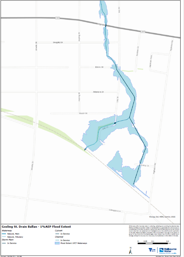
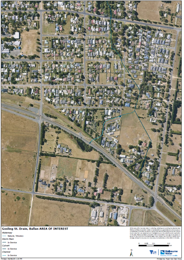
The flooding experienced in and around Lay Court and Gosling Street in Ballan is stormwater flooding. Some rain events can exceed the capacity of the drainage system in this area, leading to flooding.
Flood management in Melbourne is a shared responsibility between Melbourne Water, councils, emergency services and other key partners. We use multiple strategies to limit the impact of floods before they happen and keep you safe when they do.
Our role in managing flood risk across Greater Melbourne, including Ballan, includes:
- coordinating flood management with local government and other agencies
- understanding flood modelling and mapping
- maintaining the regional drainage system
- managing infrastructure
- monitoring flood data
- supporting planning and development
- preparing communities for floods.
For more information, visit Melbourne Water’s website: Managing flood risk together.
Local councils manage the local drainage network, including street gutters and drains. They are also responsible for:
- administering and enforcing Planning Schemes
- undertaking flood modelling and mapping of local drainage systems
- supporting local flood planning and coordinating local emergency planning
- supporting the development of local community resilience.
Councils are accountable for ensuring that their Planning Schemes correctly identify the areas at risk of a 1% Annual Exceedance Probability* (AEP) flood event, and contain the appropriate objectives and strategies to guide decisions in exercising land use controls in regard to flooding.
*Annual Exceedance Probability (AEP) is the likelihood of a flood occurring in any one year. For example, a 1% AEP flood event is a flood which has a 1% chance of occurring in any year.
Flooding can happen for a variety of reasons. The drainage system across Melbourne, including Ballan, can’t always contain larger floods. As a result, some properties in Ballan are impacted by flooding from larger rainfall events.
For example, properties in low-lying areas can be impacted by flooding as water makes its way through the catchment and into the Werribee River.
Today, new subdivisions are subject to higher drainage and flooding standards than in the past. Drainage systems designed within new subdivisions incorporate standards that can safely manage impacts from a 1% Annual Exceedance Probability* (AEP) flood event.
*Annual Exceedance Probability (AEP) is the likelihood of a flood occurring in any one year. For example, a 1% AEP flood event is a flood which has a 1% chance of occurring in any year.
The floodplain management authority (such as Melbourne Water) or local council usually collects and maps technical flood information for an area, identifying land affected by flooding, for use in Planning Schemes. The flood zone and overlays are specifically designed to identify land with flood characteristics.
While flooding cannot always be eliminated, these variables help avoid hazardous situations and guide appropriate development.
Instead of completely stopping future development, new developments are managed to not increase the impacts of a 1% AEP Annual Exceedance Probability* (AEP) flood event. Moorabool Shire Council and Melbourne Water work with the applicant for new developments to ensure this criteria can be met and this will often result in conditions being added to a planning permit if the application is successful. New developments can be rejected by Moorabool Shire Council and Melbourne Water if they don’t meet this criteria.
*Annual Exceedance Probability (AEP) is the likelihood of a flood occurring in any one year. For example, a 1% AEP flood event is a flood which has a 1% chance of occurring in any year.
There is no legislative requirement to stop houses from flooding, but planning and development processes require new homes to have floor levels greater than a 1% AEP Annual Exceedance Probability* (AEP) flood event.
For legacy developments, there are many buildings and houses in the Melbourne metropolitan area that may be impacted by above-floor flooding.
Floodplain managers, such as Melbourne Water, have strategies and funding to work towards reducing the number of flooded buildings. The work aims to improve the flood information available so that buildings susceptible to flooding are identified; then flood mitigation programs, planning processes and other strategies can be prioritised and employed to gradually reduce the number of buildings flooded.
For more information, visit Melbourne Water’s website: Prepare for flooding
*Annual Exceedance Probability (AEP) is the likelihood of a flood occurring in any one year. For example, a 1% AEP flood event is a flood which has a 1% chance of occurring in any year.
Drainage system
As our city grows and the weather becomes more unpredictable, managing stormwater safely is becoming more challenging.
Rainwater doesn’t disappear on its own. It runs off roofs and roads, into drains, creeks and rivers, and eventually into the bay. Managing that journey across a large, complex city takes careful planning, resilient infrastructure and constant maintenance.
Melbourne Water manage the city’s main drainage system, and Moorabool Council manages the local drainage system. We maintain pipes and waterways, invest in flood protection, and care for the health of our rivers, creeks and bays.
Greater Melbourne’s drainage system, including Ballan, directs stormwater away from urban areas to reduce the risk of flooding. While it can handle most storms, extreme rainfall can still sometimes cause floods.
The drainage system is made up of:
- 1,400 kilometres of regional drains, managed by Melbourne Water
- 25,000 kilometres of local drains and street gutters, managed by councils
- building roof gutters, downpipes and pipelines, which are the responsibility of property owners
- other drains managed by agencies like VicRoads and VicTrack.
Melbourne Water manages major drainage systems and waterways across Greater Melbourne, including Ballan. We work together with councils to prevent new developments or buildings from overloading existing drainage systems.
We also work together to assess whether drainage upgrades are needed and feasible, based on structural and hydraulic assessments as well as prioritisation across all of Greater Melbourne’s drainage network. Melbourne Water also carries out maintenance of existing drainage assets to ensure they are functioning well.
Moorabool Shire Council and other local councils manage the local drainage networks.
They are also responsible for:
- administering and enforcing Planning Schemes
- undertaking flood modelling and mapping of local drainage systems
- supporting local flood planning and coordinating local emergency planning
- supporting development of local community resilience.
For further information, visit the Moorabool Shire Council website.
When it rains, some water naturally seeps into the ground. To prevent the rest of the water that comes from hard surfaces such as roads, sidewalks and houses, from flowing toward low land, the drainage system directs it into rivers and streams. In Ballan the drainage system flows into the Werribee River and eventually into Port Phillp Bay.
A summary of how the drainage system works is below:
- Stormwater enters house gutters and downpipes, and flows into residential drains
- Residential drains connect to council drains along streets and roads
- Council drains connect to Melbourne Water’s regional drains
- Regional drains direct stormwater into the nearest river or creek, or directly to the bay via piped beach outlets
- Rivers and creeks flow into Port Phillip or Western Port Bay
Our teams monitor and assess the condition of drains regularly. We also rely on reports from the community such as photos and videos which can be sent to Melbourne Water.
Maintenance is prioritised based on:
- the impact on performance of a drainage asset (e.g. extent that a blockage in a drain may impact flooding)
- the chance a drain will fail
- the likely impact if it does fail
- how urgently repairs are needed to protect homes from above-floor flooding.
Find out how to contact Melbourne Water.
If vegetation is present within a drain, Melbourne Water will assess the likely risk to flooding and drainage and, when required, remove it. In general, low-lying vegetation (such as grasses) doesn’t significantly impact the capacity or flow of a drain, whereas large trees and shrubs can.
In some situations, vegetation outside the channel, such as along the banks or batter of a drain, can provide a net benefit to flood risk reduction by:
- controlling erosion by stabilising soil within the channel and along banks
- reducing sedimentation and subsequent blockages
- slowing surface runoff
- increasing infiltration.
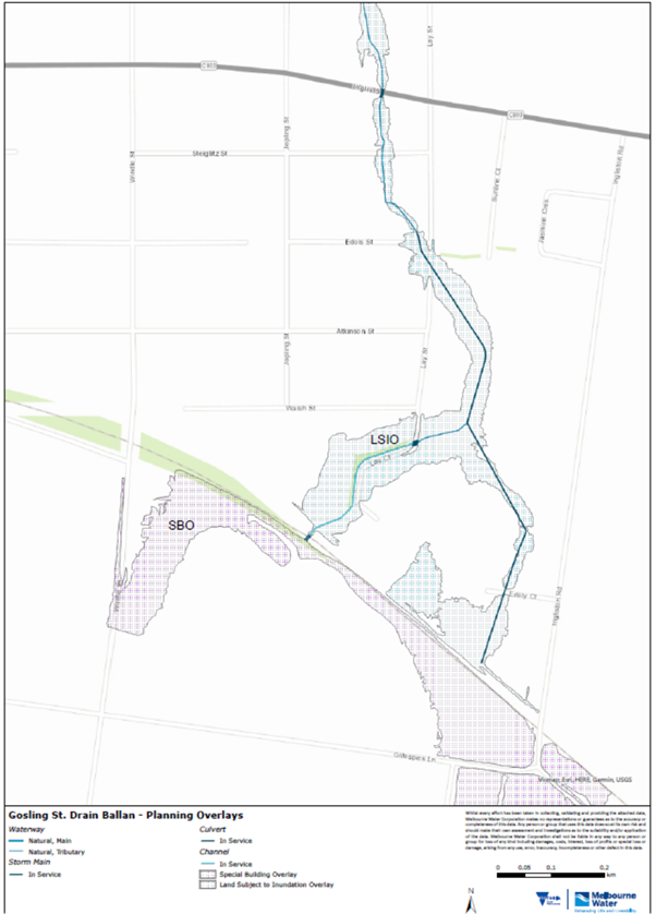
Overlays: Land Subject to Inundation Overlay (LSIO) and Special Building Overlay (SBO)
The LSIO typically applies to land affected by flooding associated with waterways and coastal areas. This overlay requires a planning permit for buildings and works.
The SBO identifies areas prone to stormwater, or overland flooding when the capacity of the drainage system is exceeded. This overlay requires a planning permit for buildings and works.
These are planning scheme controls that apply to land affected by flooding associated with waterways and open drainage systems. Such areas are commonly known as floodplains. These overlays require a planning permit for buildings and works.
The purpose of an LSIO is to ensure development effectively responds to any local flood hazards, reducing the risks of flood damage and keeping waterways clean and healthy.
LSIOs are used to:
- Keep people safe: they avoid putting buildings in the worst affected areas.
- Protect homes and buildings: they make sure new buildings are built to handle floods.
- Protect the environment: they make sure that new buildings don’t make the potential for flood damage any worse.
If your property is in an LSIO area:
- You might need a planning permit to build or make changes such as constructing extensions, building fences, swimming pools, installing large rainwater tanks, decks or subdivision of land.
- Any new buildings or big changes have specific requirements to protect them from floods, like raising the floor height or using flood-safe materials.
Your property is in an LSIO area because:
- it’s near a river, creek or wetland that floods during heavy rain
- experts have mapped the area and found it’s at risk of flooding.
You’ll need a permit if you want to:
- build a new house or shed
- extend your house or other buildings
- dig or change the land (like building a dam or pool, or filling in areas)
- cut down trees or plants if this changes how water moves during a flood
- subdivide the land.
- You can check the planning maps on Moorabool Shire Council’s website
- You can also call your Moorabool Shire Council and ask them to check for you.
LSIO maps are updated periodically when new flood studies are done and changes are made to the Planning Scheme. This can happen after major floods or when better technology is available to predict flooding.
The SBO identifies areas prone to stormwater or overland flooding when the capacity of the drainage system is exceeded. This overlay requires a planning permit for buildings and works.
Melbourne Water can provide you with a flood certificate, if you are the owner of the property, or pre-development advice, should you wish to develop land within an SBO or LSIO area or want to know if the land is flood affected.
Moorabool Shire Council are still the planning authority in these areas and you still need to contact Council to confirm whether a planning permit is required in areas covered by an LSIO or SBO.
Planning Scheme Amendments
We’re constantly obtaining new flood information for the wider Melbourne area. We provide this information to councils like Moorabool Council, so they have accurate information about land that may be affected by flooding during severe storms.
Planning schemes set policies for land use, development, and conservation. Amendments are usually led by councils or the Planning Minister (not Melbourne Water).
Melbourne Water supports councils by providing flood modelling and technical input. Planning scheme amendments, like Amendment C91 (updated in 2020 for areas including Ballan, Bacchus Marsh, and Darley), incorporate new flood data.
The amendment process usually takes 18 months and includes public consultation. Flood overlays do not stop development but ensure it is flood resilient.
Where Melbourne Water is the relevant Referral Authority, as part of an application to amend planning scheme information, overlays or a change the zoning of a parcel of land, you will require Melbourne Water consent.
The amendment applies flood extent mapping to land identified as being subject to inundation during a 1% AEP Annual Exceedance Probability (AEP) flood, within the catchments of the Werribee River, Lerderderg River and Little River, in the eastern portion of the Moorabool Shire. The amendment applies the Land Subject to Inundation Overlay (LSIO) and the Special Building Overlay (SBO), updates the Municipal Strategic Statement and inserts three new reference documents
Overlays are information on a map that indicates if a planning permit is required for the construction of a building or other changes to the land.
C91 introduced two overlays: Land Subject to Inundation Overlays (LSIO) and Special Building Overlays (SBO) based on flood modelling data from Melbourne Water.
To reduce flood risks by ensuring future development is better informed by up-to-date flood mapping.
To improve safety and resilience for the community and infrastructure in flood-prone areas.
To comply with state and regional planning frameworks for sustainable flood management.


