Real-time flood alerts
Sign up for flood warnings and alerts by downloading the VicEmergency App and setting up a Watch Zone.
There are three maps being updated in the west of Baw Baw Shire, which include the towns of Drouin and Longwarry. These reflect the different sources of flooding, and provide information used to plan for infrastructure, housing and emergencies.
| Bunyip & Tarago Rivers | |
| Lang Lang River | |
| Stormwater drains |
This work is being supported by Baw Baw Shire Council, as part of the Greater Melbourne Flood Information Program.
Council will inform you of any future consultation for other parts of the shire outside of Melbourne Water’s catchment area. This may be run by West Gippsland Catchment Management Authority.
Thank you to everyone who shared their past experiences of flooding in the west of Baw Baw Shire. Your contributions have been passed on to our flood modelling specialists, who will contact you if they have questions about the information you supplied.
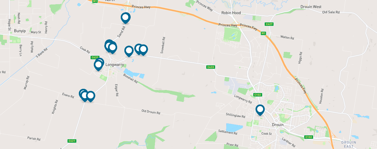
Flooding was reported at the locations indicated below.
Updating flood maps is a lengthy process that generally takes 12 to 18 months. Once this process is complete, we’ll share the updated maps for your review – so you can let us know if we’ve got them right before they’re finalised.
Drouin and Longwarry are currently at Step 2 in the process.
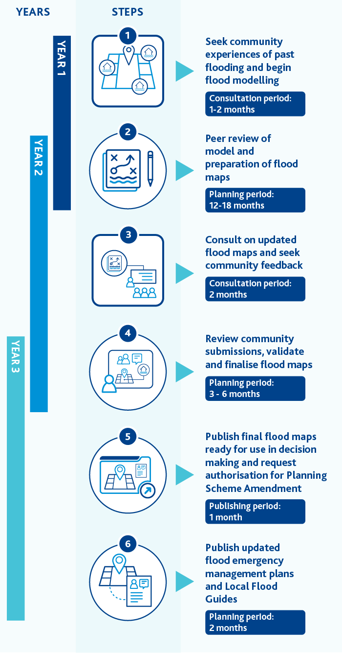
| Year | Step | Timeframe |
|---|---|---|
| 1 | Seek community experiences of past flooding and begin flood modelling | Consultation: 1-2 months |
| 1-2 | Peer review of model and preparation of flood maps | Planning: 12-18 months |
| 2 | Consult on updated flood maps and seek community feedback | Consultation: 2 months |
| 2-3 | Review community submissions, validate and finalise flood maps | Planning: 3-6 months |
| 3 | Publish final flood maps ready for use in decision making and request authorisation for Planning Scheme Amendment | Publishing: 1 month |
| 3 | Publish updated flood emergency management plans | Planning: 2 months |
To learn more about what’s involved and how the information is used, visit our flood modelling webpage.
To receive email updates on our progress, select the ‘follow’ button in the banner at the top of this webpage.
Sign up for flood warnings and alerts by downloading the VicEmergency App and setting up a Watch Zone.
The guides identify areas currently at risk of flooding. They’ll be revised with our updated flood information.
Find out about major projects and developments underway at Baw Baw Shire.
Discover what works and projects are happening in your area.
An official certificate states the estimated maximum floodwater height at your property.
Find checklists, guides and other resources to get your home or business flood-ready.
Learn more about flood maps, flood models and our program.
Understand how flooding can affect you, and how we work to minimise the impacts.
Melbourne Water respectfully acknowledges the Bunurong, Gunaikurnai,
Taungurung, Wadawurrung and Wurundjeri Woi-wurrung peoples as the Traditional
Owners and Custodians of the land and water on which we rely and operate.
We
pay our deepest respects to their Elders - past, present and emerging.


