Real-time flood alerts
Sign up for flood warnings and alerts by downloading the VicEmergency App and setting up a Watch Zone.
There are three maps being updated in the Merri-bek area, reflecting the different sources of flooding. The information they provide will be used to plan for infrastructure, housing and emergencies.
|
|
Stormwater drains Reviewing submissions – view draft map below |
| Moonee Ponds Creek | |
| Merri Creek (Lower) |
This work is part of the Greater Melbourne Flood Information Program.
Please note these maps are best viewed on a computer. If you are experiencing issues on a mobile device, try refreshing your browser.
Watch the following video for an introduction to using our flood maps, and the information they show. Please note this video shows an example map for instructional purposes only, and does not display the actual map data for Merri-bek.
Our current consultation in this area is only for Melbourne Water’s regional drains. That’s why unlike the explainer video, the map on this webpage does not display stormwater flooding from local drains managed by the council. For local flood information, visit Merri-bek City Council’s website.
Video transcript - Greater Melbourne Flood Information Program explainer video (PDF, 74KB)
Move around the map by:
Zoom into an area by:
Reset the map by selecting the house icon ![]() at the top left.
at the top left.
The map contains several layers of information: flood-impacted properties, flood hazard ratings, and stormwater flooding.
To turn these layers on or off:
To change the default map from street view to satellite view:
The current flood scenario reflects our best understanding of a flood which currently has a 1% chance of occurring in any year (the current 1% Annual Exceedance Probability). This information will be used to understand current flood risks and update VICSES Local Flood Guides and Municipal Flood Emergency Plans.
The Year 2100 flood scenario predicts the impact of future flooding, accounting for climate change. It is provided for a flood in the year 2100 with a 1% chance of occurring in any year (1% Annual Exceedance Probability). This information will be used to guide long-term planning, including council planning regulations on land use (e.g. property development and renovations).
Our flood maps contain updated information for the area, which will inform risks to individual properties. This information is currently in draft form, and is not to be used for official planning or development purposes.
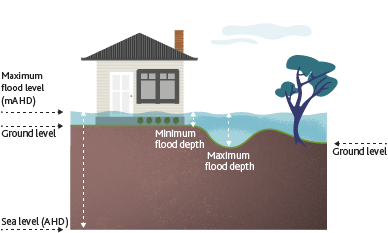
The draft flood levels provided refer to the maximum height of floodwaters, measured in metres above Australian Height Datum (sea level). AHD is Australia’s national standard for measuring elevation, and helps ensure flood information is consistent and reliable across different locations.
Even if the flood map shows your property is affected by flooding, the impact on buildings can vary. This depends on:
To find out your property’s floor level you can engage a licensed surveyor. They can also tell you if any buildings or structures are below the draft flood levels that we’ve provided.
If you need flood level information for planning or building purposes, contact Melbourne Water.
To learn more about these concepts, watch our explainer video:
We are not best placed to comment on property values or insurance premiums, as they are influenced by many factors.
Flood maps are tools for understanding the flood risk that exists – they don’t create more risk. We’re releasing this information to help plan for the future and prepare for the impacts of climate change.
These impacts are global issues that the insurance industry has been dealing with, and just one of many factors they consider when setting their premiums. We recommend contacting your insurer directly to understand your specific situation.
While flood risk is a factor in relation to property prices, it’s just one piece of the puzzle. Property values are influenced more by:
For more information, watch the following video our download our fact sheet: What does flood hazard mean for my property and premiums? (PDF, 1.4MB)
Video transcript - Addressing community concerns about flood hazard (PDF, 70KB)
The information in our flood maps is currently in draft form. It is not to be used for official planning or development purposes.
Once the updated maps are finalised and published, the year 2100 flood levels will be used for planning and building decisions in areas with existing planning and building controls (e.g. overlays).
Planning Scheme Amendments to introduce new flood overlays will be pursued separately.
We will assess planning permit and building referrals based on the flood level applicable at the time of the referral. Existing approvals will not be retrospectively impacted by the updated flood information.
However, any new or amended applications – including building permits – will be assessed against the updated flood level information, once finalised.
To understand the impacts on your renovation or development plans, refer to our flooding information and advice.
You can also download our fact sheets:
Understanding your flood risk helps us all build a safe and resilient city that’s better prepared for flooding: today and in the future.
You don’t have to wait for new flood information to find out how to prepare for a flood. It’s important for everyone to be prepared, no matter where you live or if you’ve been impacted by floods before.
In October and November 2025 we held online and in-person events to discuss our updated flood maps and what they mean for you.
Information session #1 (Glenroy)
Information session #2 (Brunswick West)
Sign up for flood warnings and alerts by downloading the VicEmergency App and setting up a Watch Zone.
The guides identify areas currently at risk of flooding. They’ll be revised with our updated flood information.
View Merri-bek City Council’s updated stormwater map for their local drainage area.
Learn how we prioritise works, and view examples of local projects.
Find checklists, guides and other resources to get your home or business flood-ready.
Learn more about flood maps, flood models and our program.
Understand how flooding can affect you, and how we work to minimise the impacts.
Find out how flooding could affect your renovation or development plans.
Melbourne Water respectfully acknowledges the Bunurong, Gunaikurnai,
Taungurung, Wadawurrung and Wurundjeri Woi-wurrung peoples as the Traditional
Owners and Custodians of the land and water on which we rely and operate.
We
pay our deepest respects to their Elders - past, present and emerging.


